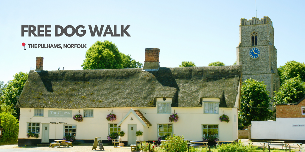
FREE Norfolk Dog Walk: The Pulhams (3 miles)
Below is a free chapter from Norfolk Dog Friendly Pub Walks. This walk (a 3-mile route around the pretty villages of Pulham Market and Pulham St Mary) is one of 20 in the book, all chosen specifically for their suitability for dogs and their owners.
The Pulhams (3 miles)
Set in rural South Norfolk, surrounded by farmland, the Pulhams comprise two villages - Pulham Market and Pulham St Mary. Often described as one of the prettiest villages in South Norfolk, Pulham Market has a large village green surrounded by thatched cottages and a medieval church. Pulham St Mary has its own medieval church and was once the site of the Royal Navy Air Service Airship Station, which later became RAF Pulham. The area is dotted with buildings once used on the airfield. This is an easy to follow route through open countryside, fields, quiet lanes and along a well-maintained pavement between the two villages. Dogs can be let off-lead while walking through the fields.
- Start & Finish: The Crown Inn, Harleston Road, Pulham Market
- Sat Nav: IP21 4TA
- Parking: Park at the Crown Inn if visiting, but please ask permission before leaving your car. Alternatively, there is roadside parking opposite and to the right of the pub on Station Road
- Map: OS Explorer 230 Diss & Harleston. Grid ref: TM 197861
- Terrain: Field paths. local lanes and a local road with pavement. There are dog bins in Station Road near the start of the walk. just before Dirty Lane. and another on leaving Pulham St Mary
RECOMMENDED PUB: THE CROWN INN is a 15th-century country inn which is owned and run by the local community. Inside, an open fireplace offers warmth in winter, and an array of comfortable chairs make it a good place to relax after a walk. Dogs are very welcome here and have their own doggy menu with delicacies including pigs’ ears and a doggy roast. The only area where dogs are not allowed is the Reading Room.
Alternatively, try THE FALCON, a small dog-friendly community pub located on The Green.

THE WALK
1. Turn left out of the pub and walk down Station Road where you will get a good view of the large stone church. There is a pavement part of the way before it enters open countryside.
In ¼ mile, turn left by the public footpath sign opposite Walnut Cottage. A dog bin can be found at this point. The path is firm underfoot and broad in places as it winds through a small wooded area of mainly deciduous trees.
The path winds to the right and crosses a small wooden bridge across a stream. Take care as there are no handholds. Turn left and walk along the wide track next to the field edge, following the lines of telegraph wires. Go through the hedge at the end of the field, crossing over a metal grid bridge.
Continue walking straight ahead along the edge of this long cultivated field, with a deep stream on the left bordered by nettles and brambles.
2. At the end of the field, you will reach a concrete and steel Bailey bridge used mainly as a storage, maintenance and salvage yard. Turn right away from the bridge and walk straight ahead past an extensive hardstanding. Ignore signs for a footpath beside a stile on the left as this leads into a field where there are usually cattle and bulls. Instead, take the left-hand turning just beyond the tree line. This is a wide, firm, flat track that was formerly part of the Beccles to Tivetshall railway line (Waveney Valley Line) which closed in 1966.
Walk on along the track following the line of telegraph wires. This is a well used, popular dog walking route passing through open fields with tall hedges on the right.
3. The long straight track eventually passes another area of hardstanding on the right-hand side, before reaching a T-junction where you turn left. There is no footpath at this point but this is a quiet road, used mainly by local vehicles. There is a dog waste bin a little further along the road on the left.
Turn right into Dirty Lane, a narrow country lane with a hard tarmac surface. Little used by cars, it is lined by tall hedges and trees and is popular with dog walkers. As the road begins to curve to the right a dog bin can be found on the left hand side.
4. At the end of the lane and 'Give Way' sign, turn left into Harleston Road and cross the little bridge. Take care because this is the main road between Pulham Market and Harleston and can be quite busy. A pavement appears on the left-hand side soon after crossing the bridge. Keep ahead as the road curves to the left, past a signpost on the far side.
The route now leads through the village of Pulham St Mary, passing the village church. Although there has been a church on this site since Anglo-Saxon times, the existing church of St Mary the Virgin dates back to the mid-13th century and has a square tower containing eight bells. It has several rare, early English sculptural elements and an impressive porch decorated with angels and an ornate pierced parapet.
Continue along the road past the village sign. Pulham St Mary was once a major site for military airships and on either side of the sign are the images of the R33 and R34 airships along with a commemorative plaque underneath telling their story. Crossing over Station Road, keep ahead past the Pennoyer Centre. Built in Victorian times as the village school, it was eventually closed in the late 20th century and later renovated as part of a community-led project. It now acts as a community centre and has a cafe providing food and drink.
5. The route is now a straight road for ¾ mile leading to Pulham Market. It passes rows of houses and an allotment before reaching the countryside. There is a dog waste bin available just after exiting the village. The pavement is quite wide, flat and firm and the road is moderately busy, mainly with local vehicles passing between the A 140 and Harleston.
On entering the village of Pulham Market, the path narrows alongside a tall wall just past the village school but then widens out as you reach the large village green. The Crown Inn can be seen on your left-hand side, just past the church and The Falcon is to your right just across the green.
This walk features in Norfolk Dog Friendly Pub Walks
- Rory Batho


Comments 0